
A geographic information systems (GIS) is a powerful relational database that stores, relates, manipulates and reports data, but it also includes a geospatial or mapping component. Where a relational database presents data in tables, graphs and charts, a GIS does that plus it stores points, lines, and polygons that can be presented on maps.
GIS is not a new science—it actually got its start back in the 1960s—but in the last decade or so, it has become more and more common in our everyday lives. For example, we use GIS applications on our phones to lookup routes and tell us how long it will take to walk, ride a bike, or drive there. We find gas stations, stores and restaurants in relation to where we are. We go to maps online to find out more about things like the spread of disease, available resources by area, and wildfires. Maps mixed with dynamic data are an effective way of communicating important trends and information, helping to answer questions and revealing patterns and relationships in data we may not otherwise see.
There are many GIS applications from which to choose, some are free and open source. But effective use of software—even free or low-cost software—requires resources that may not be available and an ongoing need that would justify the investment in an inhouse GIS system.
A GIS consultant is an effective alternative.
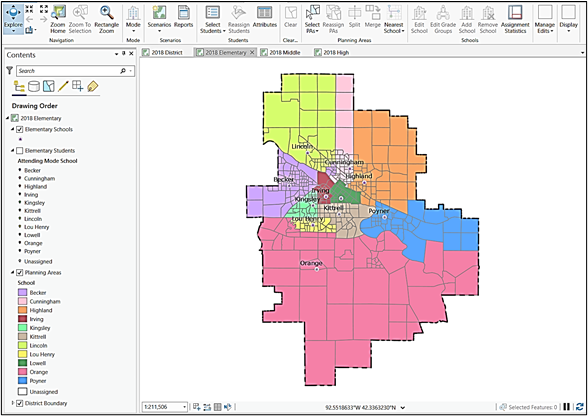
To setup the GIS to answer questions specific to your district or organization, your consultant will need to customize the GIS with your data. Data elements include points, lines, and polygons that lay on top of your geography—translation: buildings, bus stops, food pickup centers, childcare centers, students, clients, etc. (points), and boundaries of your district and internal zones such as school attendance areas or wards (lines and polygons). You will need to work closely with the consultant initially to get your data loaded. The process of inputting your points, lines, and polygons into the GIS is involved and something they specialize in so you can leave that in their hands.
Once your data is loaded, the GIS opens a world of possibilities: just ask the questions and see what answers are to be found.
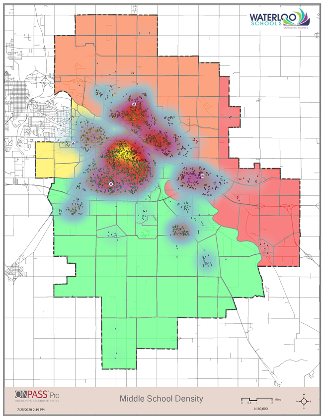
- Where do our bilingual students live in relation to our schools with bilingual programs?
- To which other schools should we assign students who attend School X that we plan to close?
- Where is the best location to build a new school given the growth in our student population?
- How do we ensure we maintain equity of services and education and minimize student travel time?
- What will be the effect on our school attendance numbers if we allow/do not allow inter- and intra-district transfers?
- How can we identify client addresses who live within our service zones so funding can be properly allocated?
- What would be the effect on bussing costs and student travel time if we increased our walk-ride buffer from one-half mile to one mile around each school?
- Where do the students live who did not show up to school and what is the quickest way we can send staff out to do a personal visit?
- What households are affected by the flooding (or fire or earthquake, etc.) in the east side of our district?
- What would be the effects of changing our school boundaries to address inequities in educational services? And, how do we best communicate the changes to the boundary lines?
- What would we see if we overlaid a map of Internet services over our students’ residences? Is there anything we can do to improve Internet access and service in poorly covered areas?
- What would we see if we overlaid a map of crime data over our students’ residences? Is there anything we can do to help with student transportation in these areas?
The questions and answers are almost endless. Find a GIS services company that will input, store, and maintain your district or organization’s geospatial data into a GIS and then remember to consider the geospatial aspects when challenged with communicating information to your stakeholders, evaluating options, and asking what-if questions.