By David Johnston, Manager, Geographic Information Systems
Have you ever thought about your school district’s boundaries—the outer district and interior school attendance boundaries? Most people don’t give them much thought except when it comes to buying a house or when the attendance zone (or catchment area) boundaries need to be changed.
Given the justifiable focus on factors that contribute directly to student success, it is easy to forget that school district administrators manage “geographic entities”1. Everything about a school district is related to geography: a location or geographic area with physical and cultural attributes.2
Students, for instance, have a home address, a school address, and attributes such as gender, ethnicity/race group, socioeconomic status, grades, attendance, educational program participation, and special needs. The district has exterior boundaries that distinguish the geographic area from surrounding districts, and often has interior boundaries for school attendance zones.
Where do digital school district boundary files come from?
The US Census Bureau takes a survey every 5 years as part of its Census of Governments.
The Census Bureau collects school district boundaries to develop annual estimates of children in poverty to help the U.S. Department of Education determine the annual allocation of Title I funding to states and school districts. NCES also uses the school district boundaries to develop a broad collection of district-level demographic estimates from the Census Bureau’s American Community Survey. The Census Bureau annually updates school district boundaries, names, local education agency codes, grade ranges, and school district levels based on information provided by state education officials3.
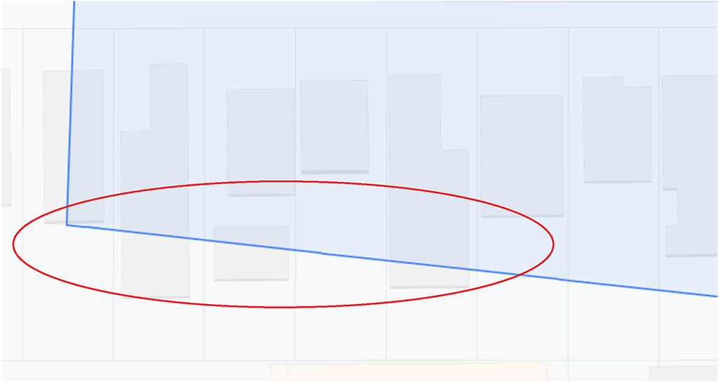
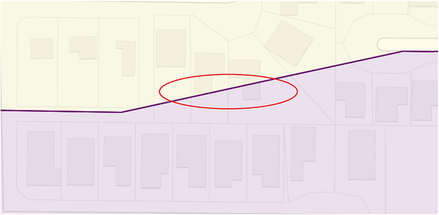
Even with annual updates, technical inaccuracies and/or practical problems can creep into the district and school attendance zone boundaries through time. For example, land is developed and where a boundary used to go through a field that had no consequences, now it cuts across a house.
About 30% of our clients have technically inaccurate boundaries, and we’ve never seen problem-free boundary files.
What are common types of boundary problems?
A boundary line that4:
- Splits a house or houses
- Creates a gap between adjacent geographic areas
- Creates an area of overlap with an adjacent district or attendance zone
- Doesn’t follow other line features such as roads; for example, the district includes addresses on both sides of a street
Problems with boundaries might feel like nuisance technicalities but they have practical importance. Accurate boundaries help ensure that:
- Students are attending school in their assigned districts
- Property owners are paying taxes in the appropriate district
- Developer fees are distributed correctly
- Information shared with other state and local government agencies (tax assessor’s office, city planners, emergency management team) is correct
How to correct inaccurate or problematic boundaries
States differ in their specific laws and regulations but in general the interior school attendance boundaries are under the control of the school district. In California for example, districts have local control and run as independent entities. They develop their own processes to adjust their schools’ attendance boundaries. Decisions generally involve the community and are made by the local school board. In some districts, adjustments can be made by administrative decision.
The outer district boundary is another story. Because the outer boundary of a district is coterminous with other districts’ boundaries, a single district does not have control over its own district boundary. Each state has detailed regulations about how boundary changes must be made. At a minimum the change process must involve the adjacent district(s). A county committee may be involved (as in California), and the state department of education often holds final change-making power.
Changes to your district boundary lines will mean that the written legal description – which is opaque and not useful for most practical purposes – must be updated, and new maps filed. Updating the written description is a job for experts: lawyers and surveyors.
Similarly, creating corrected maps is a technical problem that geographic information systems (GIS) experts can solve. The GIS specialist will start with the Census Bureau/NCES digital file, identify technical inaccuracies or other problems, and proceed with making corrections within the guidelines of local and state regulations. The corrections process can be lengthy if it involves neighboring districts, but the GIS expert cannot make unilateral decisions about where the correct boundary line is drawn.
School districts that have their boundaries and their school and student attributes in a GIS application are able to monitor their boundaries, prevent school attendance boundary problems when new housing is built, and make corrections as soon as possible when problems arise. They can also provide accurate digital files to the state and US Census Bureau.
Footnotes
1) https://nces.ed.gov/programs/edge/Geographic/DistrictBoundaries
2) http://downloads2.esri.com/edcomm2007/syfr/pres/7-Syfr-ESRI-2009-Administration.pdf
3) https://nces.ed.gov/programs/edge/Geographic/DistrictBoundaries
4) https://www.ncbi.nlm.nih.gov/pmc/articles/PMC5693243/